भारी बारिश की तैयारी कर लें दिल्ली-NCR के लोग
जारी हुआ येलो अलर्ट, जानिए कब आ रहा मानसून?
दक्षिण-पश्चिम मानसून ने देश के कई हिस्सों में अपनी पहुंच बना ली है. वर्तमान में यह लद्दाख के सभी क्षेत्रों को पार कर चुका है. भारतीय मौसम विभाग (IMD) के अनुसार, अगले दो दिनों में यह मानसून दिल्ली, चंडीगढ़, हरियाणा, राजस्थान और पश्चिमी उत्तर प्रदेश के शेष हिस्सों में भी पहुंच सकता है.
इसके साथ ही जम्मू-कश्मीर और हिमाचल प्रदेश के अन्य क्षेत्रों में भी मानसून की एंट्री तय मानी जा रही है. अगर इस बार मानसून 24 जून को दिल्ली पहुंचता है, तो यह 2013 के बाद सबसे जल्दी होगा. 2013 में मानसून ने दिल्ली में 16 जून को दस्तक दी थी, लेकिन उसके बाद से अब तक यह इतनी जल्दी कभी नहीं आया.
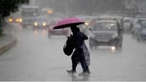
दिल्ली‑NCR में येलो अलर्ट जारी
The southwest monsoon has reached many parts of the country. Currently it has crossed all the areas of Ladakh. According to the Indian Meteorological Department (IMD), in the next two days this monsoon can also reach Delhi, Chandigarh, Haryana, Rajasthan and the remaining parts of western Uttar Pradesh.
Along with this, the entry of monsoon in other areas of Jammu and Kashmir and Himachal Pradesh is also considered certain. If this time the monsoon reaches Delhi on June 24, then it will be the earliest after 2013. In 2013, the monsoon knocked in Delhi on June 16, but since then it has never come so early.
Yellow alert issued in Delhi-NCR
As soon as the information of the arrival of monsoon in Delhi-NCR and some parts of adjoining Haryana was received, the Meteorological Department (IMD) has issued a "Yellow Alert". Light to moderate rain, thunder and strong winds are forecast in the capital Delhi, Gurugram and Faridabad today. This will see a cool and comfortable change in the weather.
Monsoon reaching Delhi early this time
According to the IMD report, the southwest monsoon may reach Delhi and surrounding areas in the next 2 days. This is three days earlier than normal - the monsoon usually arrives around June 27, but this time the weather may change by June 24.
Strong winds will blow along with rain
Yellow alert will continue for the next 2–5 days in Delhi-NCR, Gurugram, Faridabad and surrounding cities. During the alert, there will be strong winds (up to 50 km / h) and lightning along with rain. The weather has started deteriorating prematurely in different parts of Haryana.
Heavy rain alert in these places too
Apart from North-West India, the Meteorological Department has also predicted heavy to very heavy rains in Madhya Pradesh, Gujarat, Konkan and Goa till June 26. Especially on 23 and 24 June, Madhya Pradesh may receive very heavy rainfall. At the same time, heavy rainfall is also forecast in Northeast India for the next three days, after which the intensity of rain will reduce there.
Monsoon knocked in Kerala on 24 May
This year the monsoon started very early. On 24 May, the monsoon knocked in Kerala, which is considered to be the first entry after 2009. After this, it reached Maharashtra, Mumbai and Northeast states rapidly by 29 May, but from 29 May to 16 June, the speed of monsoon had slowed down. This obstruction caused an increase in temperature and heat wave, especially in North-West India.
Effect on farming
India's agricultural system is largely dependent on monsoon. The livelihood of 42% of the country's population is related to farming and it has a share of 18.2% in the GDP. According to IMD, this time between June and September, there is a possibility of more than average rainfall in the country, i.e. about 106%. However, some areas like Ladakh, North-East, Bihar, Jharkhand, Punjab, Haryana and some parts of South India may receive less rainfall.
दिल्ली‑NCR और उससे सटे हरियाणा के कुछ हिस्सों में मानसून आने की सूचना मिलते ही मौसम विभाग (IMD) ने “येलो अलर्ट” जारी कर दिया है. राजधानी दिल्ली, गुरुग्राम और फरीदाबाद में आज हल्की से मध्यम बारिश, गरज और तेज हवाओं का पूर्वानुमान है. इससे मौसम में ठंडक और आरामदायक बदलाव देखा जाएगा.
इस बार दिल्ली जल्दी पहुंच रहा मानसून
IMD की रिपोर्ट के अनुसार, दक्षिण-पश्चिम मानसून अगले 2 दिनों में दिल्ली और आसपास के इलाकों में पहुंच सकता है. यह सामान्य से तीन दिन पहले है- मानसून आमतौर पर 27 जून के आसपास पहुंचता है, लेकिन इस बार 24 जून तक मौसम बदल सकता है.
बारिश के साथ चलेंगी तेज हवाएं
दिल्ली‑एनसीआर, गुरुग्राम, फरीदाबाद समेत आसपास के शहरों में अगले 2–5 दिनों तक येलो अलर्ट जारी रहेगा. अलर्ट के दौरान बारिश के साथ तेज हवाएं (50 किमी/घंटा तक) और बिजलियों की चमक की संभावना भी बनी रहेगी. हरियाणा के अलग-अलग हिस्सों में मौसम समय से पहले खराब होने लगा है.
इन जगहों पर भी भारी बारिश का अलर्ट
मौसम विभाग ने उत्तर-पश्चिम भारत के अलावा मध्य प्रदेश, गुजरात, कोंकण और गोवा में भी 26 जून तक भारी से बहुत भारी बारिश की संभावना जताई है. खासकर 23 और 24 जून को मध्य प्रदेश में अति भारी बारिश हो सकती है. वहीं पूर्वोत्तर भारत में भी अगले तीन दिनों तक भारी वर्षा का पूर्वानुमान है, जिसके बाद वहां बारिश की तीव्रता कुछ कम हो जाएगी.
24 मई को मानसून ने केरल में दी थी दस्तक
इस साल मानसून की शुरुआत बहुत जल्दी हुई. 24 मई को मानसून ने केरल में दस्तक दी थी, जो 2009 के बाद सबसे पहले हुई एंट्री मानी जा रही है. इसके बाद यह 29 मई तक महाराष्ट्र, मुंबई और पूर्वोत्तर राज्यों तक तेजी से पहुंच गया, लेकिन 29 मई से 16 जून तक मानसून की रफ्तार धीमी हो गई थी।.यह रुकावट तापमान में वृद्धि और लू चलने का कारण बनी, खासकर उत्तर-पश्चिम भारत में.
खेती-किसानी पर असर
भारत की कृषि व्यवस्था काफी हद तक मानसून पर निर्भर है. देश की 42% जनसंख्या की आजीविका खेती से जुड़ी है और GDP में इसका 18.2% हिस्सा है. IMD के मुताबिक, इस बार जून से सितंबर के बीच देश में औसत से ज्यादा, यानी करीब 106% बारिश की संभावना है. हालांकि कुछ क्षेत्रों जैसे लद्दाख, पूर्वोत्तर, बिहार, झारखंड, पंजाब, हरियाणा और दक्षिण भारत के कुछ हिस्सों में कम बारिश हो सकती है.